Size is Relative: A Cruising Update
We spent 4 nights at Grace Harbour. At one point, for the briefest moment, we were the only people there and then suddenly there were 13 boats swinging on their anchors. The numbers varied the rest of the trip, but at no point did anyone resort to stern tying. I figure with boats stern tying, the harbour could easily accommodate another 20 boats.

It does highlight one of those cruising things that I have yet to get used to, that everything is relative. When we pulled into Grace there were only 4 boat there and, of course, the marked rock in the centre. It felt crowded. We slowly motored amongst the current occupants in search for some clear space. The next day two other boats joined us at the far end in a space we had originally estimated as only holding room for one. And so the next four days went. These sorts of distances, for me, are proving very hard to estimate and I am constantly astounded by how much in my perception size changes as the perspective does. When we left Grace Harbour there were only 10 boats but most (including the previously encountered Emerald Steel) were all crowded down at our end where I had previously sworn there was no room for more than 3 or 4.
After a pleasant night in Lund to top up tanks and batteries, where we met Alan and Charlene from Rugosa — a midnight blue Tartan 3400, stocked up on some groceries, visited the wonderful art gallery at the old hotel and had delicious cinnamon buns for breakfast, we cast off heading south down the Malaspina Strait. And for those of you paying attention, yes, we were heading into the wind. Again.

We had decided against making the six to seven hour run to Lasqueti Island and decided to break it up with a visit to Blind Bay which lies between Jervis Inlet and Agamemnon Channel. We, as usual, timed it wrong and fought the current for the first 4/5ths of the trip barely making 5.2 knots until the very last bit when it finally turned and were making 6.2 for the last few miles. There are two main anchorages in Blind Bay: Ballet Bay which had previously been recommended to us by R Shack and Hardy Island Marine Park. We decided to check out Hardy Island first since it more likely afforded someplace to go ashore and explore.
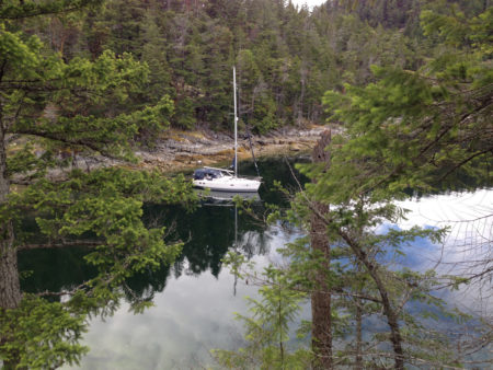
From the charts it looked like there was one notch behind Fox Island where maybe two or three boats could stern tie. As we approached there was already a lovely double-ender anchored at opening of the notch and it seemed that we’d likely only fit in one more boat. But after we dropped anchor and were settled in, we jumped in Laughing Baby to visit the oyster-laden shoals at low tide and I had a chance to reevaluate the anchorage. Now that we were tied up seemed we could easily fit another 3 or 4 boats even with that anchored sailboat taking up extra room. There were no rings or chains but the angle of the rocks made going ashore easy and there were plenty of trees to tie up to. Several other boats did come into the park, but all chose to anchor in the deeper (50ft) and more exposed water in the middle.
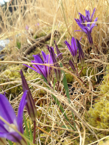
We wandered around the shore, took plenty of pictures and admired yet another crop of unknown wildflowers (turns out they were Broderiaea). Leslie emitted the most girlish squeal I have ever heard her utter when a sizeable garter snake decided her shoes were a tad bit to close. This set off a chain reaction, as I was bent over peering at some wild creeping raspberries and, startled, hopped up with extreme alacrity on the nearest rock like the storied farmwife menaced by a mouse. The snake decided we were too, too much and left.
The next morning we headed south again and, with wind (15-20 knots) and current against us, we made barely 4 knots, turning a 3 hour trip to one almost 5 hours long when all was said and done. Again after we turned around the bottom of Texada, our speed increased dramatically and we entered the small group of islands between Texada and Lasquesti that was our destination doing in excess of 6.3 knots. It would have been gterat sailing if we weren’t barely a nautical mile for our first destination. Rugosa had recommended an “unmarked” anchorage on the east end of Little Bull Channel as being especially convenient and beautiful. On the charts it looked small but as we approached it, it actually looked too open and exposed so we decided to give it a pass this time.
The Desolation Sound chart book shows some aerial photos of our next choice, which was Deep Bay on the NW side of Jedediah Island. From the air it looked like there was room for maybe 4 or 5 boats if all were stern tied on the north shore. As we rounded the corner I could see there was one boat already tied up and 2 more sets of chains on the outward side of the bay. It really didn’t look like there was much room for anymore deeper in. But, after we tied up to the outermost chains, we dinghied in and counted a total of 10 sets of chains with a couple of more on the south side. You could never convince me there is enough room for 10 boats in this tiny bay but… I guess we will have to visit in the high season to see it in action.

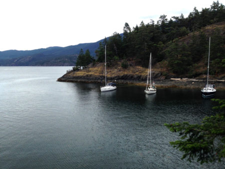
A few minutes after we were settled in a lovely Westsail 32 named Chinook came in and tied up between us and the Hunter Deck Salon that had already been here. That made three boats tightly clustered at the outside end of the bay.
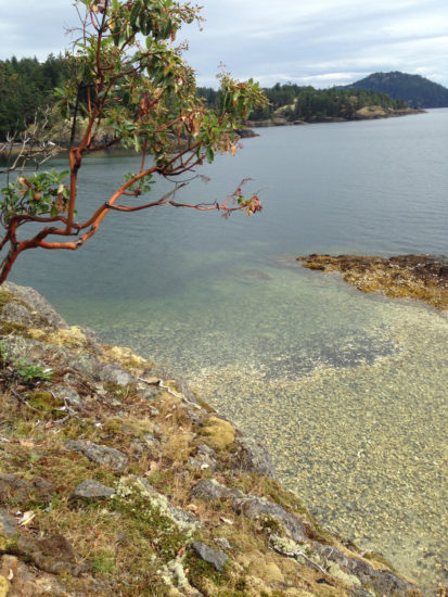
We hit the shore for a short hike to stretch our legs. The whole of Jedediah Island is a park which had been bought for the province in the mid nineties. Until then it was an active homestead and still has feral sheep and goats roaming the place. There are lots of trails and a few old buildings and the forest is relatively untouched, at least compared to most of the public lands we have hiked on the BC coast. Suffice it to say there were plenty of trees with girths exceeding 3 feet. On our way back I misremembered the map and we decided to do some bushwhacking to meet up with the trail again. This brought us to the top of Mount Jenny and then down the other side until we finally found the main trail near where we had started.
Back on board a beer was definitely in order and we availed ourselves of the hot water to shower and clean up.

The next morning both our neighbours pulled out and we had the bay to ourselves as the NW winds built. This isn’t the most recommended anchorage in a NW but since we are alone and since they are supposed to turn again this evening, we will stick it out and keep a watch. One interesting episode was when Chinook pulled up their anchor (by hand as the Westsail didn’t have an electric windlass) they also pulled up a sizeable rock (the size of a basketball) nestled in there plough anchor. This obviously made pulling the anchor that much harder and then left them with the problem of how to get it off the anchor. After 5 minutes of jiggling and poking with the boathook it finally dropped back into water with a splash and they were off to start their northward cruise. Seems they were aiming to hook up with tow of the boats we had encountered in Grace Harbour: Chatham II a powerboat that had been there when we arrived and the aforementioned Emerald Steel.
As for us, as I type this it is June 13. We have six days before we are due in Stone’s Marina to start the process of packing up. I’d still like to visit some friends in Schooner Cove on our way and also to spend some time in Nanaimo Harbour decompressing and mentally preparing for the big shift. And there just isn’t that much time left on the clock.
—Captain Why #Posts